Designed to Oppress
A history of apartheid, segregation, and colonial architecture across the world.
Oppressive architecture refers to the design and structuring of built environments that perpetuate segregation, control, and discrimination based on ethnic, religious, or racial lines. In analyzing separation architecture and design in South Africa, Ireland, and Palestine, we see how physical spaces have been manipulated to enforce social divisions.
The systems that strive to separate the peoples deemed “different” from the ruling class are a hostile design concept, and those who create these systems with that goal, should not call themselves architects, planners, or designers. Nobody has ever drawn a line across another’s land with anything but malice in their heart.
South Africa
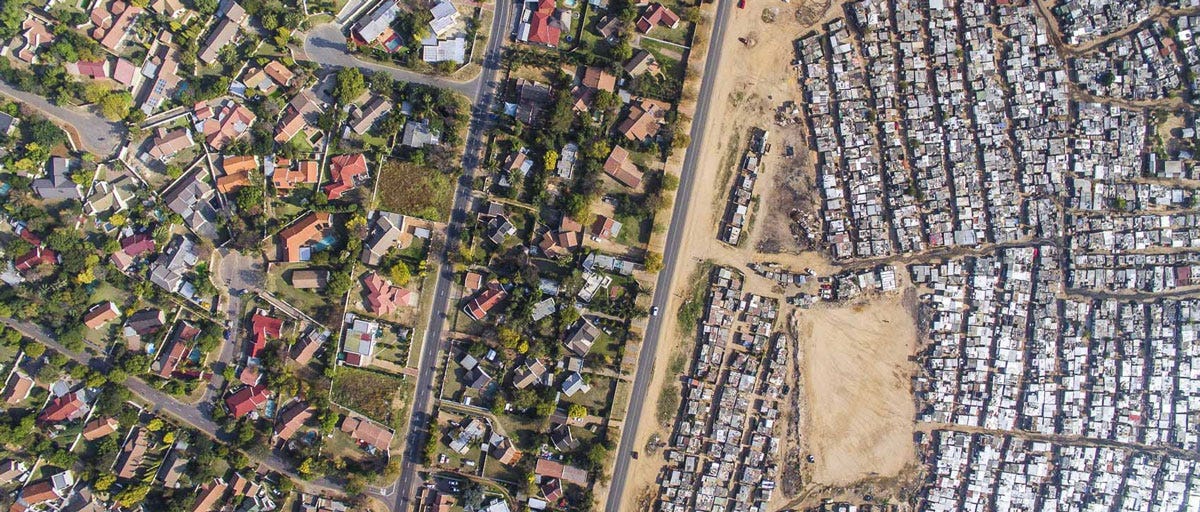
South Africa is the most well-known example of apartheid architecture, where the government implemented policies from 1948 to 1994 that mandated racial segregation. The Group Areas Act (1950) designated separate urban zones for different racial groups, often resulting in the forced removal of non-white communities. Notable features of apartheid architecture from South Africa include segregated neighborhoods, buffer zones and barriers, and many different control measures.

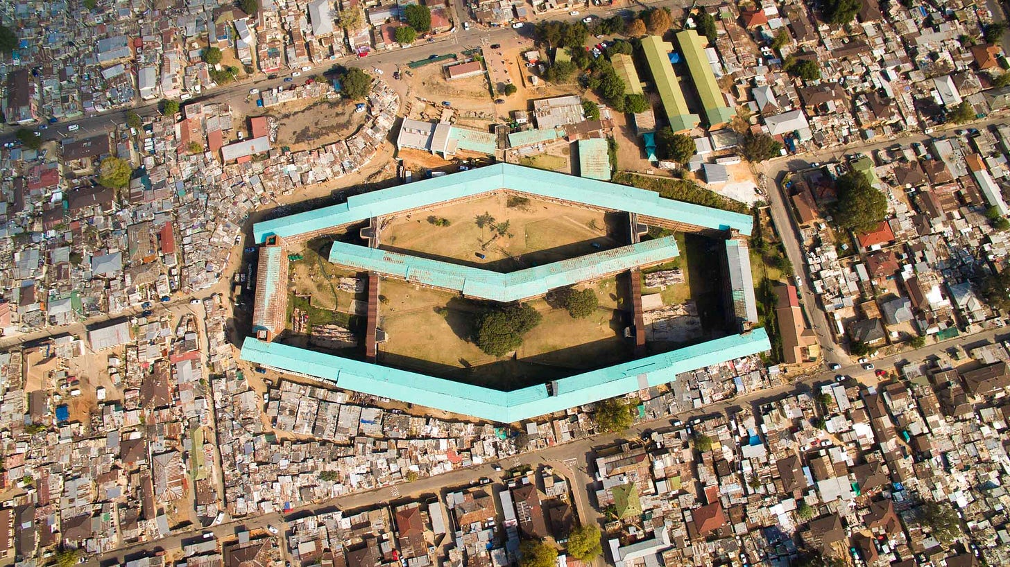
Black, Colored, and Indian people were confined to townships or rural homelands far from economic centers, while white citizens lived in well-serviced urban areas. Highways, railways, and industrial areas were strategically placed to physically separate racial groups, minimizing interaction and reinforcing divisions. Townships were designed to limit mobility, with few exit points and surveillance. Infrastructure like public transport was inadequate in non-white areas, making it difficult to access employment or services in cities. Another characteristic of apartheid in South Africa is Hostels. Hostels in South Africa were large urban housing developments, designed specifically for the black citizens of the country, Hostels could house up to 5000 people at a time, conditions are dirty and overpacked, there are little to no services including water or electricity and a lot of the residents are unemployed. Apartheid architecture's legacy persists in the spatial inequalities and urban planning challenges that still affect South Africa today, where former townships often remain economically marginalized.

The design of townships often prioritized control over community needs, resulting in inadequate housing, limited public transport, and insufficient sanitation services. Many townships still suffer from poor infrastructure, impacting residents’ quality of life. Public transport systems were designed to facilitate movement for white citizens, leaving many black residents with limited access to efficient transport options, exacerbating isolation from economic centers.
The effects of apartheid architecture in South Africa are deep-rooted, influencing the social fabric, economic conditions, and urban landscapes of the country. While post-apartheid policies aim to redress these inequalities, the challenges posed by the physical legacy of apartheid remain significant, requiring ongoing efforts to create inclusive, equitable urban environments. Addressing these impacts necessitates a comprehensive approach that considers historical injustices while promoting sustainable and integrated urban development.
Ireland
In Ireland, the architectural manifestations of apartheid can be seen in the urban design and spatial segregation along religious and political lines, primarily between Catholic and Protestant communities. The situation in Ireland can be described as a self-segregation, as the two communities have always separated from each other. However, Great Britain has imposed colonialism onto the Emerald Isle for centuries. Britain's long history of colonization in Ireland, from the 12th century until the 20th century, involved various forms of social, political, and economic discrimination against the native Irish population, with significant effects on land ownership, political representation, and social mobility. While not a legalized system like South African apartheid, spatial division has had similar impacts. Peace walls and barriers, segregated housing, land policies, and many symbolic structures, symbols and signs are some of the built features in Ireland that reflect the oppression that has been inflicted. While the era of turmoil in Ireland, deemed “The Troubles” is technically over, there’s still a lot of invisible divides between the Irish population.
The English and later British government implemented plantation policies from the 16th century, particularly in Ulster. Lands were confiscated from the native Irish, predominantly Catholics, and given to Protestant settlers from England and Scotland. This laid the groundwork for a divided society, with the Protestant population holding most of the land and wealth, while Catholics were often dispossessed. By the 19th century, a small number of Protestant landlords owned most of the land, while Catholic tenants faced higher rents, economic exploitation, and eviction. These policies marginalized the Catholic population economically and socially.
Housing policies in Northern Ireland were often biased, with public housing allocated disproportionately to Protestant communities. Since local government officials controlled housing decisions, they could favor Protestants and restrict Catholic access to housing in certain areas, maintaining segregation. Cities like Belfast and Derry developed starkly divided neighborhoods. Catholic and Protestant communities lived separately, with tensions often erupting into violence during times of political unrest. Housing segregation contributed to maintaining a divided society.
Since the late 1960s, the British government erected barriers, known as "peace walls," in cities like Belfast to separate Catholic and Protestant neighborhoods. These walls were initially intended to reduce inter-communal violence, but over time they became symbols of division, reinforcing physical and psychological segregation. Despite the 1998 Good Friday Agreement, the number and height of peace walls increased in some areas, indicating that the underlying divisions had not been fully addressed.
While the term "apartheid" is most commonly associated with South Africa, British policies in Ireland, particularly in Northern Ireland, created a society marked by segregation, inequality, and sectarian division. These policies laid the foundation for the sectarian conflict known as the Troubles and continue to influence the region's social and political landscape. The legacy of these divisions remains a challenge for reconciliation efforts, with physical and cultural barriers persisting in many areas.
Palestine
In Palestine, especially in the occupied territories, architecture and urban planning have been utilized as tools of control, fragmentation, and segregation. The architectural practices employed here are characterized by separation barriers, settlements, bypass roads, land seizure, and checkpoints.
The West Bank's archipelago-like structure, created by Israeli settlements, military zones, and the separation barrier, is fragmented into numerous enclaves due to the Israeli separation barrier, checkpoints, and Israeli settlements. This fragmentation isolates Palestinian towns and villages from each other, making travel between them difficult. Palestinians face numerous physical barriers, including the separation wall, military checkpoints, and roadblocks, which hinder their ability to move freely. These restrictions disrupt daily life, making it difficult to access work, education, healthcare, and social services.
The placement of the separation barrier and settlements often cuts Palestinians off from valuable agricultural land, water resources, and other economic assets. This limits their ability to sustain livelihoods and contributes to economic hardship. Checkpoints and barriers disrupt trade and commerce, making it challenging for businesses to operate efficiently. The unpredictability of travel times due to military checkpoints and road closures further hampers economic activity, leading to higher costs for goods and services.
The construction of the separation barrier, settlements, and bypass roads has resulted in the confiscation of agricultural land and the uprooting of olive trees, a vital part of Palestinian culture and economy. Restricted access to farmland further reduces agricultural productivity. Some Israeli settlements dump untreated wastewater and solid waste into nearby Palestinian areas, causing environmental damage and health risks. Palestinian communities often lack the resources to address these environmental problems.
Palestinians face numerous bureaucratic obstacles when trying to build or expand homes, leading to frequent demolitions of structures deemed "illegal" by Israeli authorities. In contrast, Israeli settlers enjoy a streamlined process for construction and development. The denial of building permits and subsequent home demolitions are used as a tool of displacement, furthering the fragmentation of Palestinian communities and forcing people into already overcrowded areas.
The effects of oppressive architecture in Palestine are far-reaching, shaping daily life and exacerbating inequalities between Palestinians and Israelis. The physical barriers and infrastructure perpetuate a system of control and segregation, with severe consequences for Palestinian social, economic, and psychological well-being, on top of the current humanitarian crisis and genocide happening in Palestine. Addressing these impacts requires not only changes to physical infrastructure but also political solutions against Israel that address the underlying causes of division and conflict.
Comparative Analysis
Despite differing historical contexts, oppressive architecture in these regions share common themes. All three cases utilize physical barriers to control populations, whether through walls, checkpoints, or strategically placed infrastructure. Apartheid architecture enforces spatial segregation, ensuring that groups live apart and experience different levels of access to resources and opportunities. Architecture is used to assert dominance or reinforce identity, with physical markers indicating territorial claims or community boundaries.
The legacies of oppressive architecture in South Africa, Ireland, and Palestine continue to shape social relations and present challenges for reconciliation and integration. While urban policies may evolve, the enduring physical structures can perpetuate divisions long after official policies have changed.
In the United States, similar practices of spatial segregation and control have manifested through policies like redlining, urban renewal, and highway construction, which have disproportionately affected marginalized communities, particularly Black and Latin populations. Redlining, a practice from the mid-20th century, restricted access to housing and loans for people in minority neighborhoods, leading to economic disparities and lasting residential segregation. Urban renewal projects often displaced communities of color, while highways were strategically built to divide neighborhoods, limiting access to resources and reinforcing segregation. These practices echo the oppressive designs from all over the world by using physical barriers and planning policies to maintain social and economic inequalities, perpetuating a cycle of segregation and disenfranchisement.


